How and why dose the intraplate strain become focused in discrete zones is a first-order problem in geodynamics? Such heterogeneous intraplate strain is exemplified in central Asia, where the Indo-Eurasian collision has caused widespread deformation while the Tarim block has experienced minimal Cenozoic shortening. The apparent stability of Tarim may arise either because strain is dominantly accommodated by pre-existing faults in the continental suture zones that bound it—essentially discretizing Eurasia into microplates—or because the lithospheric-scale strength (i.e., viscosity) of the Tarim block is greater than its surroundings. On the other hand, the mechanism for the large igneous province in Tarim is a hot topic.
Recently, Dr. DENG Yangfan from Guangzhou Institute of Geochemistry, Chinese Academy of Science, Dr. Will Levandowski from USGS and Prof. Tim Kusky from China University of Geosciences, jointly analyze seismic velocity, gravity, topography, and temperature to develop a 3-D density model of the crust and upper mantle in this region.
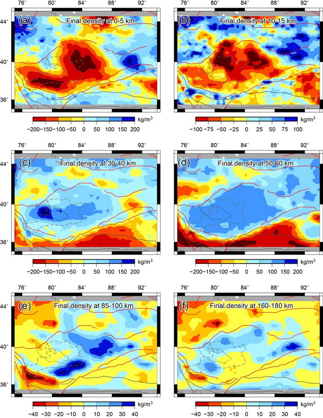
The results show 1) The Tarim crust is characterized by high density, vs, vp, and vp/vs, consistent with a dominantly mafic composition and with the presence of an oceanic plateau beneath Tarim. 2) Low-density but high-velocity mantle lithosphere beneath southern (southwestern) Tarim underlies a suite of Permian plume-related mafic intrusions and A-type granites sourced in previously depleted mantle lithosphere; they posit that this region was further depleted, dehydrated, and strengthened by Permian plume magmatism. 3) The actively deforming western and southern margins of Tarim—the Tien Shan, Kunlun Shan, and Altyn Tagh fault—are underlain by buoyant upper mantle with low velocity; they hypothesize that this material has been hydrated by mantle-derived fluids that have preferentially migrated along Paleozoic continental sutures. 4) Strain focuses because of lithospheric-scale variations in rheology rather than the pre-existence of faults in the brittle crust.

Figure Final density model averaged over the 1000 simulations. The mean has been removed from each layer. (Image by DENG Yangfan)
Deng, Y.*, Levandowski, W., Kusky, T., 2017. Lithospheric density structure beneath the Tarim basin and surroundings, northwestern China, from the joint inversion of gravity and topography. Earth and Planetary Science Letters 460, 244-254.
http://www.sciencedirect.com/science/article/pii/S0012821X16306161
Contact:
Dr. DENG Yangfan
Guangzhou Institute of Geochemistry, Chinese Academy of Sciences
Email: yangfandeng@gig.ac.cn
